Follow Us

Menu
Log in


Log in

Updates

  • 08 Nov 2022 4:53 PM | Steve Peterson (Administrator)

    If you were unable to attend our Annual Meeting August 6th, here is the link to the Zoom recording. Like many meetings, the recording started before the meat of the meeting started, so it takes a bit before your get the beginning of the meeting. Also, you'll need to copy and paste the Access Passcode below

    Topic: 10:00 AM Saturday August 6, 2022 PLIA Annual Meeting

    Start Time: Aug 6, 2022 09:30 AM

    Meeting Recording:

    https://us02web.zoom.us/rec/share/M8Ch-KPE4SQ-IhkwWdXYPAHP6DsNwLYpX7OcH7VO1mhEfpV7AxhL0Q_gAAuFoGg-.d6YOP5mmciT5_51m

    Access Passcode: hp+kF7#G


  • 04 Aug 2022 9:02 AM | Steve Peterson (Administrator)

    Here’s the Minutes of last year’s Annual Meeting.

  • 08 May 2022 5:44 PM | Steve Peterson (Administrator)

    Some Platte Lake residents have experienced their shoreline being pushed up by the ice. So, how does this happen? Well, several physical properties can work together to “shove” ice toward your shoreline. Temperature fluctuations, changing water levels and the prevailing wind can all contribute to push ice onto the shore with considerable force. This force has been known to move houses off of their foundations, push boulders the size of SUVs and snap trees in half. Do we have your attention?


    As you know, Platte Lake covers 2,516 acres, is 3.3 miles long and roughly 1.6 miles wide. When temperatures decrease, this large ice sheet contracts, forming stress fractures. Water from below fills these cracks, freezes and expands the ice sheet. When temperatures rise, the ice expands, as well. Lastly, changing water levels also cause the ice to crack, cracks, again, fill with water, freeze and the ice sheet continues to expand. Unfortunately, this happens all winter long, continually expanding the ice sheet. It just keeps getting wider.

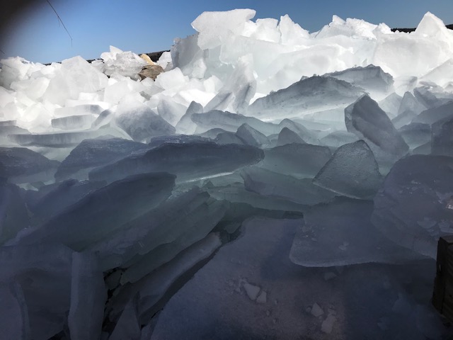
    Prevailing wind also comes into play. Typically, the land temperature causes the water near shore to freeze last and thaw first causing a huge, very heavy, floating ice sheet on the lake. The bigger the lake, the more force the wind can apply to push this heavy mass of ice toward shore. You see this in the summer in the form of bigger waves.

    So, what can you do to protect your shoreline? Landscapers recommend a 3:1 slope, meaning a gradual rise of 1 foot for every 3 feet of shoreline. This will create a ramp for the ice to slide on top of the ground rather than pushing up against it. This will also reduce erosion from wave action once the ice is gone. Please know that it is your responsibility to obtain all necessary permits before you begin any shoreline work.

    Here's a TV feature from Minnesota:

    at www.youtube.com/watch?v=XsqbZCq2cT4


  • 19 Feb 2022 5:10 PM | Steve Peterson (Administrator)

     Here's the link to the info.

  • 10 Feb 2022 5:08 PM | Steve Peterson (Administrator)

    John Ransom of the Benzie Conservation District, normally does all our lake and tributary sampling.  He's recently become a licensed drone pilot, and shot footage recently of the Lake and tributaries in February. Here's the link:

    https://youtu.be/KluW02C_AKM

  • 03 Feb 2022 6:30 PM | William Anderson (Administrator)

    The State of Michigan has created a webinar that describes best practices for shoreline management: Advancing Inland Lake Stewardship through Shoreline Best Management Practices https://attendee.gotowebinar.com/recording/8970175820341110535.

  • 03 Feb 2022 6:19 PM | William Anderson (Administrator)

    Here is a link to a webinar from EGLE describing how they are using a new technology eDNA and qPCR to identify native and invasive species in Michigan lakes. https://attendee.gotowebinar.com/recording/930290611830040847


  • 28 Oct 2021 11:06 AM | Steve Peterson (Administrator)

    The policy, which is more comprehensive, isn't really a new one. Here's the link to it, if you'd like to take a look.

Powered by Wild Apricot Membership Software